
(This was a neat grad-school class project to learn about the non-uniqueness in solutions to this problem, UW Geophys 503, Spring 2002)
Analysis of Gravity Measurements
and Gravity Gradient Differences on the Seattle Fault
Andrew A. Ganse
Applied Physics Laboratory, Seattle, Washington
15 June 2002
Abstract. Gravity data were measured across the Seattle fault zone, on the east and west sides of Lake Sammamish, near Seattle, WA. Large gradients are seen in the data, about 50 mgal on the west side of the lake (“Bellevue” data) and about 30 mgal on the east side of the lake (“Issaquah” data). The data are compared to a mathematical horizontal slab model for a vertical fault, and while fault modeling of gravity data offers no unique solution, the measured data and its differing gradients between the two tracks are roughly consistent with a model that uses the change in depth of the Seattle basin seen in other data sources.
1. Introduction
The Seattle fault zone consists of several parallel east-west reverse faults through the greater Seattle area. It forms the steep southern edge of the Seattle basin, a bowl-shaped vertical boundary between less-dense sedimentary rock layers nearer the surface and the denser volcanic rock below (Figure 1). At the fault zone this volcanic rock layer, called the Crescent Formation, is suddenly uplifted, creating a large, lateral density contrast between the uplifted Crescent Formation to the south of the fault zone, and the sedimentary layers to the north (Johnson et al, 1994). The particular interest in the Seattle basin and the fault zone lies in the possibility of its being a seismic hazard, in which the basin acts as a resonator for seismic energy radiating from the fault zone. Measuring gravity anomalies at the ground surface at various points over the Seattle basin is one way these underground structures are seen; seismic tomography and boreholes also yield significant information about the area. However, even with much analysis and synthesis of the data from these different methods, the exact nature of the fault zone remains somewhat elusive (Johnson et al, 1994). The analysis presented here of new gravity data taken by students of the University of Washington’s Earth and Space Sciences Department is just one piece that lends support to other parts of the puzzle.
2. Measuring the Gravity Data
Gravity data were measured using a Lacoste and Romberg geodetic gravity meter (L&R #G213, UWser. #167654) along two north-south tracks across the Seattle fault zone, on the east and west sides of Lake Sammamish. The west track (“Bellevue” track) follows the path of a geological slice seen in a USGS geologic map of the area, between 148th Ave SE and 164th Ave SE to the north of I-90, and through the Hilltop area to the south of I-90. The east track (“Issaquah” track) follows perpendicular to I-90 along 228th Ave NE to the north and Front Street to the south. Measurements were also taken at the reference station in the basement of Johnson Hall (“JHN”) at the University of Washington for calibration and as a common base station for comparisons. Two measurements were taken at each location and averaged together for the data used in the analysis, and position and elevation were recorded via handheld GPS (except for the JHN basement station position and elevation, where there was no GPS reception but position and elevation were previously known). The data were measured on four different dates by three different collection teams, with two different GPS receivers. The GPS receivers have an accuracy in both position and elevation of 15 meters, and in some locations elevations were not recorded via GPS and instead were inferred from a topography map, also with an accuracy of approximately 15 meters. Uncertainty in elevation is the strongest factor in the uncertainty of the reduced gravity data values. The above elevation accuracies make the reduced data accurate to only approximately 4.5 mgal, so data comparisons and conclusions must be drawn on a somewhat broad scale, such as that of the Seattle basin’s change in depth.
3. Data Reduction
The measured gravity meter units were converted to milligals and then corrected with latitude, free air, and Bouguer plate corrections and referenced to the Johnson Hall reference station at the University of Washington. For more precise surveys one would also correct for tides, terrain changes, and instrument drift, but these corrections are found to be insignificant at the several-milligal accuracy considered. Tidal corrections are generally on the order of hundredths of milligals, the instrument drift is seen in the data to be on the order of tenths of milligals, and the terrain correction can also be neglected if terrain changes near the measurement locations are within 5% (Milsom 1989), as was purposely made the case for our data.
For the latitude correction, the standard formula for relative measurements of 0.814 sin(2l) mgal/km is used, which at Seattle’s latitude (l) gives a correction of 0.812 mgal/km northward in the measurement locations. The free air correction is 0.3086 mgal/m above sea level. The Bouguer plate correction is 0.0419 r x 10-3 mgal/m -- since the Bouguer plate correction is for additional surface rock above sea level, and in this area that surface rock is less-dense Quaternary deposits with an estimated density of 2200 kg/m3 (Danes et al, 1965), the Bouguer plate correction is then 0.092 mgal/m elevation. The gravity data for both tracks with all three of these corrections applied are shown in Figure 2. Note the approximately 50-mgal gradient in the Bellevue track and the approximately 30-mgal gradient in the Issaquah track, and compare with the differing basin depth gradients in Figure 1 along those tracks (on either side of Lake Sammamish on the right side of the figure).
4. Mathematical Modeling of the Data
The data are compared to a mathematical horizontal slab model for a vertical fault (Lowrie 1997). While fault-modeling of gravity data offers no unique solution, the measured data are roughly consistent with this simple mathematical model which uses the change in depth of the Seattle basin inferred from seismic and borehole surveys. This model assumes a step function in the rock density to represent the uplift of the fault; the dip of the fault is neglected and assumed vertical, so the Seattle basin becomes a rectangle (Figure 3). While this model is certainly simplistic, it yields results that roughly compare with the measured data. The formula used is that for the gravitational anomaly of a horizontal slab (Lowrie 1997):
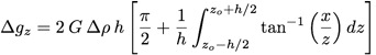 (1)
(1)
Δgz is the change in gravity seen over this fault, G is the gravitational constant, Δρ is the difference between the two densities used in the model, h is the thickness of the slab in the horizontal slab model, z0 is depth to the center of the horizontal slab, and x is the horizontal range across the surface. To turn this slab model into our rectangular basin one, we choose h=2z so that h becomes the depth of the basin and z0 is its half-depth.
As seen in Figures 2 and 3, this rectangular basin model roughly matches the measured Bellevue data given a density difference of Δρ = -350 kg/m3 and a basin depth of 6 km, and roughly matches the measured Issaquah data given a Δρ of -300 kg/m3 and a basin depth of 3 km. The basin depths for these areas are taken from Blakely et al, 2000, to try to constrain them to reality. The general scale of the density differences is inferred from rock layer profiles suggested by Johnson et al (1994) and Yount et al (1991) and layer densities from Danes (1965). Note that the Bellevue track required a greater density difference to match the data than the Issaquah track. While a roughly one-kilometer layer of less-dense Quaternary sediments is shown to be on the surface of moderately-dense sediments in the basin (Yount et al 1991), and could bring down the average basin density, this model is extremely simplistic and it is cautioned to draw too many conclusions from it. However, this model does lend support to the size of the uplift of the Crescent Formation shown in Johnson et al 1994 and Blakely et al 2000, and the tapering of the basin to the east.
Acknowledgments. My thanks to my classmates in Geophysics 503 at the University of Washington for our working together to collect, reduce, and discuss the gravity data, and to Adrienne Sherhart and Dirk Bush for additional assistance in data collection on the Bellevue track.
References.
Blakely, R., Brocher, T., and Wells, R., How the jello-shakes depends on the shape of the bowl: a three-dimensional view of the Seattle Basin, poster at the Great Cascadia Earthquake Tricentennial Open House, January 26, 2000, Burke Museum, University of Washington, Seattle WA.
Danes, Z., and nine others, Geophysical investigations of the southern Puget Sound area, Washington, J. Geophys. Res., 70, 5573-5579, 1965.
Johnson, S., Potter, C., Armentrout, J., Origin and Evolution of the Seattle Fault and Seattle Basin, Washington, Geology, 22, 71-74, 1994.
Lowrie, W., Fundamentals of Geophysics, pp. 46-81, Cambridge University Press, Cambridge, 1997.
Milsom, J., Field Geophysics, pp. 26-38, Halsted Press, New York, 1989.
Yount, J., Gower, H., Bedrock Geologic Map of the Seattle 30’ by 60’ Quadrangle, Washington, Open-File Report 91-147, USGS, 1991.
Tables
Table 1. Gravity Data Along Issaquah and Bellevue Track
ISSAQUAH:
date       time  easting  northing elev  mgalsraw anomaly
05May2002  0730  0551892  5278179   29   4502.74    0.00
10May2002  1235  0572499  5266021   23   4526.81   29.61
10May2002  1251  0572506  5265576   31   4529.09   33.98
10May2002  1307  0572510  5264982   40   4530.22   37.55
10May2002  1320  0572455  5264679   29   4531.61   36.80
10May2002  1332  0572492  5264194   34   4533.75   40.41
10May2002  1347  0572592  5263600   52   4534.23   45.27
10May2002  1403  0572576  5265753   36   4527.90   33.73
10May2002  1538  0572512  5267409  123   4500.97   24.29
10May2002  1630  0572499  5266021   23   4526.93   29.74
10May2002  1703  0572492  5270345  141   4497.75   22.59
10May2002  1720  0572640  5270941  120   4499.24   19.05
10May2002  1733  0572546  5271795  181   4487.34   19.66
10May2002  1753  0572500  5273460  120   4500.75   18.52
10May2002  1806  0572418  5274211  113   4498.91   14.56
10May2002  1823  0572301  5268651  127   4497.14   20.32
10May2002  1834  0572456  5269474  122   4502.29   23.72
10May2002  1843  0572489  5270346  133   4497.85   20.96

BELLEVUE:
date       time  easting  northing elev  mgalsraw anomaly
18May2002  1330  0551892  5278179   29   4505.75    0.00
18May2002  1425  0564174  5265546  195*  4498.57   38.98
18May2002  1520  0564165  5266131  175*  4498.81   34.41
18May2002  1540  0565195  5267082  360*  4443.42   18.30
18May2002  1600  0564865  5268057  220*  4471.76   15.55
18May2002  1618  0564955  5268944  135*  4487.15   11.82
18May2002  1632  0565191  5269530  117*  4491.32   11.62
18May2002  1655  0563971  5264437  229   4499.47   48.13
18May2002  1750  0551892  5278179   29   4505.75    0.00
19May2002  1620  0565198  5269523  119   4491.27   12.01
19May2002  1628  0565330  5270319  111   4493.42   11.78
19May2002  1645  0565445  5271310  94    4495.57    9.46
19May2002  1703  0565857  5272143  84    4492.37    3.41
19May2002  1717  0566019  5272787  99    4489.91    3.68
19May2002  1734  0566314  5274106  125   4484.25    2.58
19May2002  1752  0565194  5269528  108   4491.34    9.70
*GPS elevations were not recorded at some locations and elevations
there were taken from USGS topography map.
Position in UTMreWGS84 easting & northing (meters), elevs in meters.
2 GPS units used, Garmin Etrex and geophys dept's Garmin unit.
Both GPS meter manuals say accuracy is 15m.
Figures
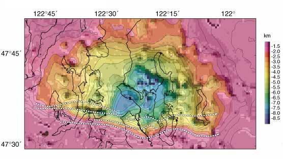
Figure 1. Depths to the basement interface of the Seattle basin, with map and Seattle fault zone lines superimposed. Lake Sammamish is the rightmost body of water shown in the diagram, and the two tracks of data were taken on the west and east sides of it, across both fault lines shown. (Reproduced from Blakely et al, 2000.)
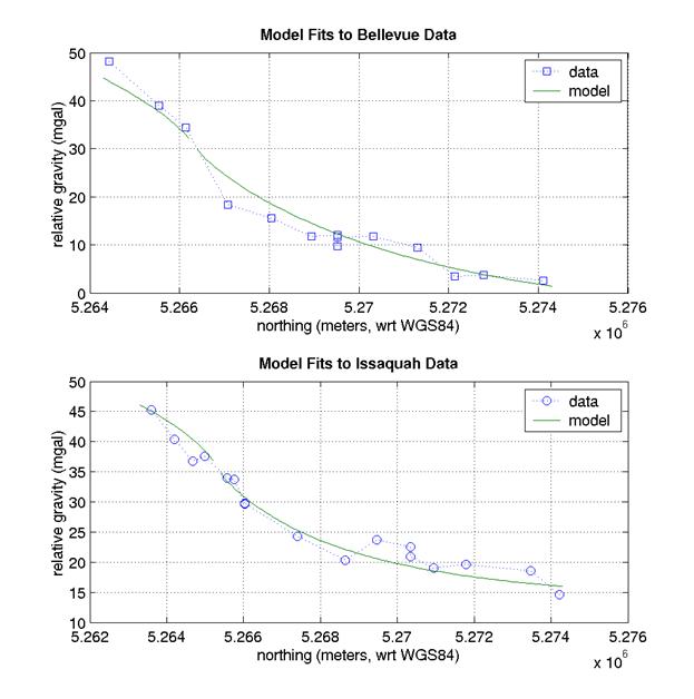
Figure 2. Plots of the measured data and matching model results for the Bellevue and Issaquah tracks.
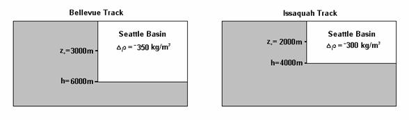
Figure 3. Diagrams to explain the model parameters for the Bellevue and Issaquah tracks. The gray area represents the denser Crescent Formation that is uplifted at the Seattle fault zone.